Geography
![]()
Tibetan Plateau from Space
NASA Visible Earth Project: The Tibetan Plateau (incl. small, medium and large satellite images)
Mountains and Glaciers
Mt Everest as seen from the International Space Station (NASA Image of the Day)
Mt Everest in 3.8 billion pixels, a project of GlacierWorks (also view the image here)
More spectacular interactive imagery from GlacierWorks: Explore Everest and Rivers of Ice
Geology of the Tibetan Plateau
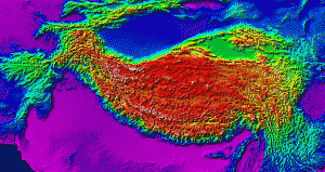 “Tibet has often been called the ‘Roof of the World.’ The plateau is probably the largest and highest area ever to exist in Earth history, with an average elevation exceeding 5000 m (16,400′). In the image, high elevations are shown in reds, and low elevations are shown in blues. The Tibetan Plateau covers an area about half that of the lower 48 United States and is bounded by the deserts of the Tarim Basin (Tarim) and Qaidam Basins (Q) to the north and the Himalayan, Karakoram, and Pamir mountain chains to its south and west. Its eastern margin is more diffuse and consists of a series of alternating deep forested valleys and high mountain ranges that run approximately north-south, bounded by the lowlands of the Sichuan Basin of China.
“An excellent site about the geology of Tibet and the Himalayas is at: http://www.geo.arizona.edu/~ozacar/frontp~1.htm, which is the source for the images used on this page.” (Source: James H Wittke, http://oak.ucc.nau.edu/wittke/Tibet/Plateau.html)
Nature Reserves and other protected areas
See here.